
Plumber in the world’s largest national park
Mastering of details is necessary to describe an entire arctic ecosystem, including the amount of carbon flowing with the rivers to the nearby fjord and the number of greenhouse gases exchanged between soil and atmosphere.
They have no pipe wrench or cleaning tape, the two geographers Kirstine Skov and Laura Helene Rasmussen. Instead they master several other advanced tools out here in the arctic wilderness.
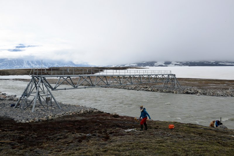
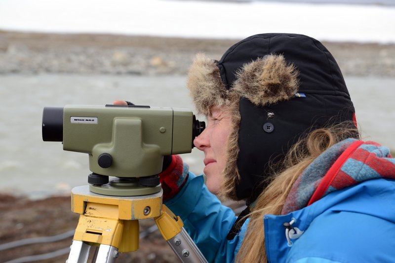
And you need to watch your step when determining the water level of the Zackenberg River. Kirstine Skov adjusts the bubble level to horizontal while Laura Rasmussen holds the gauge at the fixed measurement spots. Afterwards they record the depth of the river by pulling a so-called Q-liner across the river. With sound waves, it measures the water depths despite the turbidity of the water.
Kirstine and Laura have stayed at Zackenberg Research Station many times for several years and are permanent team members of the so-called Geobasis-programme focused on measuring the physical environment in the atmosphere, soil and rivers.
Geobasis is one of five comprehensive monitoring programmes routinely undertaken in the Zackenberg area. The four others are: Biobasis, Marinbasis, Klimabasis and Glaciobasis. Each year very detailed datasets are compiled and made available to all researchers and managers working with arctic environmental issues, and the data sets represent some of the longest time series in the world.
Roaring river
The Zackenberg River, flowing next to the field station, is the largest river bringing fresh water to the nearby fjord, Young Sund. Throughout winter the river is frozen and no fresh water reaches the fjord. But in the beginning of June the ice breaks up and the river is rapidly transformed from a snow-covered area to a roaring river that carries the winter’s snow and ice into the fjord.
With the ice come nutrients and carbon from the soil, affecting the environmental conditions of Young Sund. Fresh water is lighter than salt water and therefore moves as a surface flow from the fjord towards the Greenland Sea, while simultaneously bringing in salt water from the Greenland Sea – water which moves over the bottom into the fjord. Scientists predict that warmer Arctic summers will result in more precipitation, primarily in the form of snow, and that the amounts of precipitation will vary notably from year to year. This may change the flow conditions in the Greenland fjords.
Carbon from the soil reaches the fjords via the area’s multiple watercourses. In the fjord the added carbon is included in the marine nutrient cycle. In order to calculate an overall carbon budget for Young Sund, it is important to know the quantity added and the quantity produced in the fjord itself. And when you have obtained detailed knowledge of an ecosystem, models can be developed and upscaled to understand the basic mechanisms of the entire arctic area.
Automatic chambers
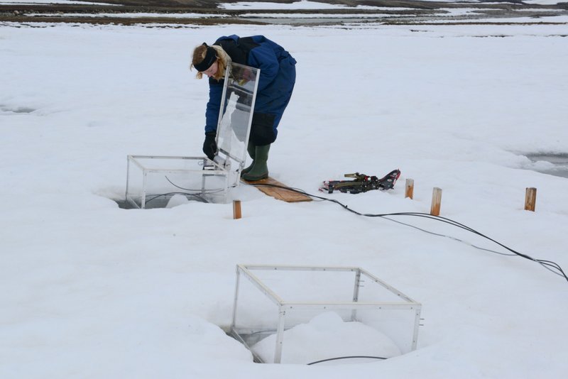
At the Zackenberg tundra Kirstine and Laura each day inspect ten transparent, square-shaped boxes or chambers inserted firmly into the ground. Every third hour a lid automatically closes the box for eight minutes after which it opens again.
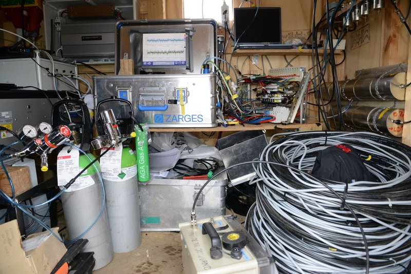
During these eight minutes measurements can be made in the atmosphere above a small area of enclosed tundra (ca. ½ m2) in which gas is sucked up in long tubes to an infrared gas analyzer in a nearby hut. This allows the scientists to calculate how many greenhouse gases the arctic tundra releases to the atmosphere and under which conditions the release is highest.
The ice thaws during the last days of June and until the soil is covered by ice again, advanced tools placed in the hut every third hour record the exchange of the greenhouse gases carbon dioxide, methane and water vapour between atmosphere and soil.
There is permafrost in the tundra – from a certain depth and downwards the soil is permanently frozen all the year round. But the upper layer which thaws in summer is getting deeper and deeper with the increasing temperatures and the prolonged arctic growing seasons. At Zackenberg the scientists have measured that the transition zone between thawed and frozen soil has penetrated another 20 cm into the ground during the 16 years of the research station’s existence. This corresponds to an increase of 30%.
Gas source
When the soil thaws, the turnover by microorganisms of the carbon hidden here starts. During this process the bacteria produce, among other gases, carbon dioxide and methane. Methane is formed when the oxygen conditions of the soil are limited. Simultaneously, gas bound in the frozen soil is released.
Actually, a very large quantity of the global carbon pool is stored in the frozen soil. Not least in the wet tundra where Kirstine and Laura work. The scientists fear for the extent of the future pool to be released, enhancing the level of greenhouse gases in the atmosphere.
Previous years’ data reveal that the release of methane and carbon dioxide varies significantly throughout the year and depends strongly on the wetness of the soil. However, ca. two weeks after the ice melts and at dry soil conditions, the release of gases is typically high.
A few years ago the scientists spotted a pronounced methane release in autumn when the soil freezes from both the top and the bottom. This ‘blocking’ of the soil squeezes the gas out of the soil from both top and bottom, resulting in the release of large quantities of gas to the atmosphere. In the first year when this release was observed, the scientists noted that the release during a short-term autumn period was just as large as the release during the remaining part of the year. Methane as a greenhouse gas is approx. 20 times as aggressive as carbon dioxide.
Read also: Sermitsiaq: Gas- og vandmester i verdens største nationalpark (Danish / Greenlandic)
Further information
Magnus Lund, Department of Bioscience, Arctic Research Centre, Aarhus University. ml@dmu.dk, tel. +45 87158404
Kirstine Skov, Department of Bioscience, Arctic Research Centre, Aarhus University. ksk2@dmu.dk
and Laura Helene Rasmussen, Department of Bioscience, Arctic Research Centre, Aarhus University. qdb775@alumni.ku.dk
Torben R. Christensen, Department of Bioscience, Arctic Research Centre, Aarhus University. torben.christensen@nateko.lu.se, tel. +46 709563743
Mikhail Mastepanov, Department of Physical Geography and Ecosystem Science, Lund University. mikhail.mastepanov@nateko.lu.se.